THE AREA

With this small brochure, the Mercurio sul mare hotel wants you to savor what is the promontory of Capo Vaticano and the neighboring area of Tropea, a place that offers so much from a landscape, food and wine, historical and cultural point of view.

Sea

You will immerse yourself in crystal clear waters with a multitude of shades. On this excursion you will get to know one of the most beautiful stretches of the Tyrrhenian coast, known as the Costa degli Dei, for its suggestive views: white beaches, coves, small caves, cliffs and on the horizon Sicily and the beautiful Aeolian islands. 15 km around the promontory of Capo Vaticano, from the bay of Santa Maria to the bay of Tropea, with relaxing stops and swimming in the most enchanting places.

Santa Maria

The splendid bay of Santa Maria is home to the only fishing village in the Capo Vaticano area.
Popular tradition divided it into three areas: Fortino, Santa Maria and Petrario. In the center of the bay a small church was built in a square surrounded by a few houses inhabited by fishermen. This suggestive was originally dedicated to the Madonna della Misericordia and cared for by the Jesuit fathers of the college of Tropea. In the 17th century it became a country church for peasants and fishermen. During the 18th century it was enlarged and dedicated to Santa Maria di Loreto (1731). It was destroyed during the French occupation to obtain a stone for the construction of a military fort (the Fort). In 1815, after the defeat of the French, the inhabitants of Ricadi rebuilt it, increasing its height and length. In 2000 it was erected as a sanctuary. Restored in 2002 and equipped with the bronze door (the sea gate) in 2008.

Grotticelle

The bay of Grotticelle, wide and indented, divided into a series of small bays, culminates with the Palombaro rock, the extreme point of Capo Vaticano, from where a lighthouse has indicated the safe way to sailors since ancient times. The bay of Grotticelle and its splendid beaches are universally classified among the most beautiful in the world. At the top, a viewpoint has been created that enjoys a view that is nothing short of wonderful.

Praia i focu - Vaticano - Mantineo

The enchanting Praia i focu beach follows, in the heart of Capo Vaticano, the Vatican name derives from Vaticinium, a Latin term that means oracle, response. Tradition has it that in the cave between the Capo cliff and the Mantineo rock, the Sibyl named Manto (presence attested by the name of the rock) lived. It is said that the sailors, before facing the tremendous vortices of Charybdis and the jaws of Scylla, addressed her and Ulysses himself, escaped from Scylla and Charybdis, stopped here to ask the mantle for the answer on the future that awaited him. . The Praia i focu beach, located at the foot of the Cape, under the lighthouse, is one of the 100 most beautiful beaches in the world and one of the 10 most beautiful in Italy. From the public accessible only by sea, while a private staircase connects it to the lighthouse and the Berto house, the writer who, arrived in the 60s, attracted by this splendid place, chose it as his home.

Torre Ruffa

Torre Ruffa follows a stretch of coast that takes its name from the lookout tower located high up on the cliff. This tower was part of the defensive system wanted by Charles V and the viceroy of Naples Pietro Alvarez and is the last of the four towers (S. Maria, Vatican Ruffa and Bali) falling within the Ricadi territory. Its construction began in May 1589 and finished at the end of the century. These towers were guarded 24 hours a day by towers that signaled the arrival of pirate ships, during the day with the smoke and at night with the fires. It is said that in this locality lived a rich and beautiful noblewoman, named Donna Canfora, who, with deception, was captured by the Saracens. The noblewoman, seeing herself lost, resorted to a stratagem, with the excuse of a last farewell to the coast, to her native land, to her friends, she threw herself into the sea shouting: "the women of this land prefer death to dishonor" . Donna Canfora appeared among the waves and from that day, at that point, the waters of the sea became a changing blue like the shades of the veil she wore. Even today, the waves that break on the shoreline spread to the adjacent countryside and the peasants pass on the legend that that roar is nothing more than the lament of the beautiful kidnapped woman who greets her land.

Torre Marino

Continuing you arrive at the bay of Torre Marino, name derived from a fortified house with a tower that stands on a 52m high tufa rock, overlooking the sea, built around the seventeenth century, by the Tranfo family, a noble family who came to Tropea in the first mid-16th century, still today the heirs spend their holidays there, around this stately house a small village rose up, with 28 inhabitants, which took the name of Torre Marino together with the district and the beautiful beach, white and thin sand, and a transparent sea to variegated. Above there is an expanse of flat land where the red Tropea onion is grown.

Riaci

Here is the enchanting bay of Riaci with its blue bottoms and transparent waters, it takes its name from the stream that flows into it, Riace which derives from the Greek and means impetuous stream. A stratified rocky wall rises above the sea, the long white sand beach is divided by a small promontory that goes into the sea: the Riaci rock with caves and inlets to swim through. It is said that, during World War II, the rock was bombed by the Germans who from afar mistakenly mistaken it for an enemy ship.

Grotta Azzurra

Here is the Blue Grotto, also known as the Skeleton Grotto because its reflection of the sun on the sand creates a play of colors that, projected inside the cave, take on skeletal shapes. The beach is called Pietre di Mulino because, as can still be seen today from the many round hollows in the rock, the stones were extracted and ground by the mills. This stretch of coast is given the name of Passo del Cavaliere. It is said that a beautiful mermaid went up on the rocks every day to warm herself in the sun. A knight who passed by attracted by her enchanting face dived into the waves trying to reach her but he drowned.

Tropea - Island

In front of the cliff of Tropea, a well-known and important tourist center, stands a large sandstone rock, once surrounded by the sea, on which stands the medieval Benedictian sanctuary of Santa Maria dell'Isola still today under the jurisdiction of the Benedictian order of Montecassino. The rock until a few years ago was linked to the cliff by an arched bridge, now demolished to widen the road along the seafront. Of considerable interest is the large cave that across the rock, called the Lovers' Cave, because according to the legend inside it, two men in love with a beautiful woman, to obtain the conquest, clashed in a mortal duel.

Tropea - Rupe

The excursion ends at the foot of this 50m high cliff overlooking the sea, on which Tropea, a town of 6200 inhabitants, stands. A real balcony overlooking the sea, an elegant center and narrow streets characteristic of medieval centers, ancient palaces of the Tropeana nobility, the bishop's palace and the Cathedral, 12th century, with its marble sarcophagi and a painting of the Madonna of Romania, protector of city. Today Tropea welcomes thousands of tourists, from all over the world, attracted by the natural, scenic, artistic beauties and its food and wine products.
In addition, every morning it will be possible to take a WATER TAXI that will accompany you to the famous COVES, which are among the 10 most beautiful beaches in Italy and among the 100 most beautiful in the world, of "PRAIA I FOCU" in the extreme tip of Capo Vaticano . The bright white sand with a sandy bottom, the crystal clear sea with its marine fauna and flora, fish, caves, dwarf palms and wild goats will enchant you by offering you an unforgettable experience.

Diving

As previously mentioned you can also do some fantastic dives where you will admire our fantastic seabed.
We illustrate them below.

Cliff of the Galea

The southernmost of the diving spots in the Capo Vaticano area is the Scoglio della Galea. The dive leads south of the outcropping rock, to a maximum depth of 19 meters. A chain of rocks and small rocks rests on the bottom of light sand, creating an infinite number of cracks that make up the ideal den for groupers, corvine and white bream. The shaded walls are covered with colorful sponges and lined with many varieties of algae. The rock of the Galea is perhaps the most characteristic of the diving spots of Tropea, the one that summarizes all the peculiarities of this sea: clear water, great brightness and rocks covered with multicolored sponges.

Scoglio Mantineo

Immediately below the lighthouse, near the shore, the Mantineo rock is another good diving spot, sometimes beaten by the current. The emerging rock is the most impressive of a series of submerged rocks that rest on the sand at a depth of 15 meters. A very pleasant second dive, suitable for divers of all levels, who with an attentive eye will be able to discover all the benthic organisms of our Mediterranean: sponges, tunicates, bryozoans, a quantity of nudibranchs, crustaceans and gobies and blenny overlooking their many in the rocks. The passages between the different rocks, in the presence of current, allow you to observe entire schools of mullet, small in size but very numerous, stationed motionless on the bottom in the most sheltered points with the nose facing the current.

Scoglio del Vadaro

The rock of Vadaro has its roots in the sand at a depth of twenty meters. Underwater we will be able to circumnavigate the rock which, on the northern side (the one facing Tropea, so to speak) falls on the sand with a landslide. Here too the numerous ravines among the stacked rocks give shelter to octopuses, groupers and white fish in general, while amberjacks are often sighted in open water, especially in September.

Formicoli

Between Riaci and Torre Marino, about 300 meters from the coast, a series of outcropping rocks emerge from the surface: they are the Formicoli, what remains, it is said, of an ancient Roman port. Pleasant and not too deep the dive: the Formicoli continue underwater towards the open sea giving life to a ridge of rocks and small rocks that rest on the sand at a depth of 18 meters. It is the ideal habitat for groupers, white breams and, between October and November, corvine: each of the thousands of dens that are created among the submerged stones hosts some animals, so much so that this is one of the "good addresses" for spearfishing enthusiasts. . A tunnel opens up between the rocks, in which it would be good not to pass in order not to ruin the fragile animals that live attached to the rock: but if you really do not want to give it up, at least be careful not to bump against the walls and hold your breath until you will be under the vault, so as not to emit air bubbles which, trapped in the vault, would condemn even the most resistant organisms to certain death. A very pleasant and peaceful dive, this one, suitable for beginners but also interesting for experts. Further out to sea, at a depth of 27-30 meters, the sene of rocks closes with the external shoal of Formicoli.

La Rete

Beyond Capo Vaticano opens the Grotticelle beach, interrupted in the middle by a series of outcropping rocks. An underwater reef rises from the bottom of the Grotticelle: it is the shoal of Monaco, here called Smalidittu probably due to the quantity of nets that the rock has snatched from the fishermen. One of these submerged mountains is called, precisely for this reason, the Net. It is a deep dive: the top of the shoal is 38 meters deep and the walls, which fall for about twenty meters on the sandy bottom, are quite "Bald": no gorgonians but many red sea squirts. On the other hand, here you will find an exaggerated quantity of cicadas, even large ones. The shoal is surrounded by a series of other deeper shoals that rest on the sloping sandy bottom and which form large cracks, chosen as a den by large groupers, and submerged arches.

L'Ancora

Half buried in the sand of the sandy plateau that forms the bottom of Le Grotticelle, at a depth of forty meters, a Roman anchor emerges covered with encrusting sponges and bryozoans. The anchor is placed right on the edge of the fall towards the underwater valley that creeps into the Grotticelle up to a short distance from the coast, a sand hill supported by a rocky wall on which dense colonies of bryozoans and sponges live.

U Vapuri

About thirty meters deep in front of the town of Riaci lies the U 'Vapuri wreck, clearly visible, silhouetted against the clear sand, right from the surface in the clear water. Of the ship, of which little or nothing is known, all that remains is the metal skeleton: sheets that rise to a maximum of 50-60 cm from the bottom and it is for this reason that identifying U 'Vapuri with the sounder is certainly not an easy task. Although only the skeleton of the ship remains, the dive is still pleasant: among the plates hide groupers, large octopuses and sometimes even the triggerfish, for the local "pig fish", unusual in the Mediterranean.

Excursions

In a short time you can visit places of undoubted historical, landscape and cultural value in the area including Capo Vaticano, Tropea with its fantastic island, Pizzo calabro and Nicotera with its castles, Vibo valentia and the Greek walls, Serra San Bruno and the charterhouse and the caves of Zungri. You can rent electric bicycles of our property to reach the destinations located near the structure at a cost of 15 euros per day or be accompanied by our transfer service. For info and reservations ask at the reception.

Eolie Islands

During the day it is possible to go to the Aeolian islands, islands with a wild and fascinating aspect, especially at night, when it is possible to see the incandescent lava flow of the active Stromboli volcano. Below we illustrate the various excursions.
Stromboli – Panarea – Lipari
Departure from Port of Tropea at 7.30
Arrival in Stromboli at about 9:15 am.
Stop on the island of about 1.30 hours.
Departure from Stromboli at approximately 10:45 am
Arrival in Panarea at about 11:30.
Stop on the island of about 1.30 hours.
Departure from Panarea around 1:00 pm
Arrival in Lipari, port of Marina Corta, at approximately 1:45 pm.
Stop on the island of about 2.30 hours.
Departure around 4.15pm
Arrival at 19:00 at the port of Tropea
Stromboli – Lipari – Vulcano
Departure from the port of Tropea at 7:30 am
Arrival in Stromboli around 9.15 am
Departure from Stromboli around 10.45 am
Arrival in Lipari, port of Marina Corta, around 12.15 pm
Free stop of about 2 and a half hours
Departure from Lipari at about 2.45 pm
Arrival in Vulcano around 3:00 pm
Departure from Vulcano around 4.30 pm
Expected return at 19.10 Tropea
Panarea and Stromboli by night
Departure from Port of Tropea at 10:45 am
Arrival in PANAREA at approximately 1:15 pm
Stop of about 2.30 hours
Arrival in Stromboli at 16.35.
Stop for about 3 hours
Departure at 20:00 for the "Sciara del Fuoco" (Fire Road), to admire the nocturnal eruption of the active volcano.
Arrival at 22:50 at the port of Tropea.
Stromboli by night
Departure from the port of Tropea at 2.20 pm
Arrival in Stromboli at 16:00, disembarkation at the small port of San Vincenzo.
Departure from Stromboli at around 7.15 pm, once boarding is complete, you will arrive near the "SCIARA del FUOCO" where you will stop for 30 minutes. about so that you can admire the eruption of the volcano.
Expected arrival at the Port of Tropea at around 22:00

Nature

You will discover that the promontory also has a green hilly heart behind it to explore, ideal for lovers of nature and panoramic views. Below we illustrate the places with the prices to reach them.

Monte Poro

Monte Poro is a mountain in Calabria that rises on the Tyrrhenian side between Angitola, Mesima and the Serre. They differentiate it from the other Calabrian massifs: the mild climate, the varied vegetation and the dense population distributed in small villages. Its modest altitude, of only 710 s.l.m., allows anthropization even in the highest area. It is also an important center for the transmission of radio and television signals due to its position that embraces the entire Tyrrhenian coast from Cetraro in the north to Scilla in the south and the plains of Lamezia Terme to the north east and Gioia Tauro to the south east.

Aspromonte

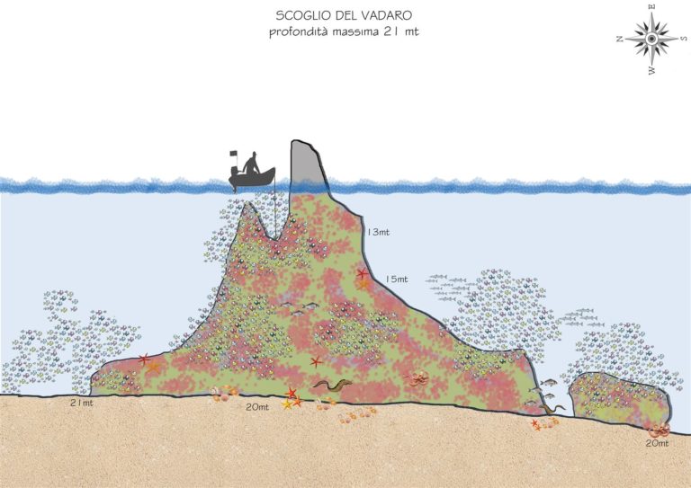
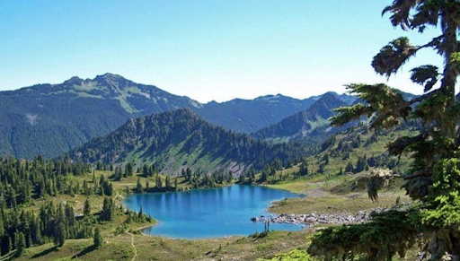
The Aspromonte (in Calabrian Asprumunti or Spremunti) is a mountain massif of the Calabrian Apennines, located in southern Calabria, in the province of Reggio Calabria, limited to the east by the Ionian Sea; to the west from the Tyrrhenian Sea, next to the Strait of Messina, and to the south from the Petrace river and the rivers of Platì and Careri. For many scholars, the natural border of the northern area is the Passo della Limina (822 m), at the foot of Monte Limina (888 m); the toponym Limina, from the Latin limen, indicates the border point, where the Aspromonte massif ends (Aspromonte National Park) and the Calabrian Serre chain begins. The name Aspromonte has two possible etymologies. In addition to the obvious meaning of "rugged mountain" which would describe its morphology, another possibility is the meaning of "white mountain", from the Greek term sour, which means white. On its slopes there is the last community of speakers of the Greek language, an ancient language that derives from ancient Greek or Byzantine Greek, for which both etymologies are plausible. The highest peak is Montalto (1,956 m), of gentle shapes, made up of archaic rocks (gneiss and micascists). Almost all the buttresses descend steeply towards the sea, so that the coastal strip is very narrow. Characteristic is the development of the Aspromonte with overlapping terraces; four levels are recognized, called planes or fields. The vegetation is very rich and varied. On the basal level there is the Mediterranean scrub, with several floristic consortia often unique, which diversifies a lot with respect to the exposure. On the Ionian belt there are often xerophilous formations, formed by thorny gorse (Ulex europaeus) and fiber gorse (Spartium junceum), which coexist with the mastic, the myrtle, the perastro and, in the humid areas, the tamarisks. Going up, high spots or real woods are formed, mainly composed of oaks and holm oaks. In the middle areas there are chestnut and pine forests, which progressively, together with the larch pine, are brought up to greater heights, where the beech dominates the tree cover. In the coastal area citrus fruits, vines, olive trees and horticulture predominate; under 1,000 m there are oak and holm oak woods, and above 1,000 m there are larch pine, silver fir and beech. At 1,311 m stands the ski resort of Gambarie, with a flow of tourists from Calabria and Sicily. In an impervious valley in the heart of the Aspromonte, in the municipality of San Luca, is the Sanctuary of the Madonna di Polsi, a place of worship which, although difficult to reach, becomes a destination for religious tourism in the summer months, especially in September.

Sila

La Sila (in Calabrian dialect Sìela) is a vast plateau of southern Italy, located in the central-northern area of the Calabria region (Calabrian Apennines), which extends for 150,000 hectares through the provinces of Cosenza, Crotone and Catanzaro, divided from the north to the south in Sila Greca, Sila Grande and Sila Piccola and characterized by the presence of various mountain peaks, plateaus, dense wooded areas and artificial high-seas lakes. Seat of the oldest national park in Calabria, the Sila National Park and the related body were established by decree of the President of the Republic of 14 November 2002, which includes the territories already falling within the "historic" national park of Calabria (1968), protecting areas of significant environmental interest for a total of 73,695 hectares. Entry into the collective imagination for its woods and mixed coniferous and deciduous forests, its plateaus, its rounded peaks, its lakes, the great snowfalls, the stable presence of wolves, the seasonal presence of porcini mushrooms, in an environment that at times it recalls the Nordic-Scandinavian one, from the highest peaks, depending on their position in the plateau, it is possible to see on clear days the Aspromonte to the south and the Pollino Massif to the north, the Tyrrhenian Sea to the west, the Ionian Sea to the east, the plain of Sibari to the north, the Piana di Sant'Eufemia and the Piana di Gioia Tauro, Sicily, Etna and the Aeolian islands to the south.
We hope to have aroused your curiosity to discover a strip of coast, which in any case cannot be fully enjoyed through the brief description of our brochure. A territory, this of the Vatican Capo area, which must be experienced. Only in this way, you will realize that the Vatican leader leaves emotions…. forever. Don't forget to go to our barar where you can find typical local products.